


Þórsmörk Hikes (Part 3): Nauthúsagil, Eyjafjallajökull and Stakkholtsgjá
- Zak Goldstein
- May 1, 2023
- 3 min read
Updated: Dec 19, 2023
Three tiny hikes on the way back from Þórsmörk, a canyon, a grove and a volcano. Nothing but prettiness as we go from one to the next along F249.

DINK Details
Three tiny hikes off the same road. The deets are a sum of all 3 hikes.
Difficulty: Easy (all 3) Month: Sept | Time¹: 4.5 hours Distance: 3 mi Elv. Gain: 400 ft |
Obstacles: - Balancing with rope support over water - F249 F-Road² | Prep: Water resistant wear |
1. How long we took to walk it with breaks and all
2. Requires F-class vehicle.
So this thing went off only 8 years ago? *Checks calendar*
Getting To Trailhead(s)

All of these hikes and sites are right off of F249. Nauthúsagil is the first and has no river crossings. Eyjafjallajökull and Stakkholtsgjá do require multiple river crossings which vary depending on the weather.
Each has parking but you need a proper F-class vehicle. There are multiple river crossing which range in danger.
More can be read about F249 in our TODO article.
The Hikes
These hikes will be listed in order from closest to furthest from route 1 as someone coming from Reykjavik or Vik. We came from so this is the opposite of our itinerary.
Nauthúsagil Canyon

Hike Time: 45 min
A canyon overgrown with trees from above and moss from below. There are two paths 1) through the canyon, walking over the stream 2) walking above. We went through the canyon, highly recommended.


Some sheep guarded the entrance to the canyon. After some staring, we were granted access.


Obstacles
Nothing crazy here. Some stream crossing so get those waterproof shoes or get wet. Some sections will have you hug the wall with rope assistance (or chains) as you shuffle past the stream. Here is Neas scaling down the tiny foss to saftey.


The rest of the trail was some rock hoping and smooth sailing. We got to say hi to another couple on their way out.


The Foss (Waterfall)
The payoff is grand. A little canyon to ourselves, hidden from the world.

Eyjafjallajökull Volcano
Hike Time: 20 min
Yep a volcano. Not just any volcano but the one that shut down European air traffic in 2010 (8 years prior to this hike). Must touch it.

Obstacles
The river crossing start on your way here. Watch the weather and the waters.
If there are any volcano obstacles, you are on your own.....
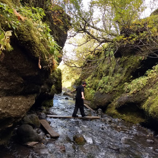
Stakkholtsgjá Canyon
Hike Time: 1 hour
A canyon with cliff walls raised 100 meters above us, twisting into the distance. A small stream from waterfalls we would soon see. The shape and size of this place was unique, making this one of our favorite easy hikes.
We followed the stream towards the source, exploring little caves and enjoying the sunlight reflecting off the water.


We eventual come to a turn in the stream. If you head straight past it for 30 seconds, there is a cave.


After the cave, we attempted to follow the stream. The sun and waterfalls were so pretty, I felt compelled to give up being dry and walk into the stream. We had to stop eventually since the ground disappeared. (Image at top, low quality gif here)

Obstacles
The most potentially dangerous river crossing is between here and the volcano. Watch the conditions.
Your feet will get wet.
Wrap Up
After a many little pretty hikes, we went to the south shore to stay at a new area for us, Eyrarbakki. I am sharing this because I got to meet this gentleman!!

His name was Johnny Cash because he wont stop singing.
In the Area
Volcano Huts

Details
Stay the night! So much hiking
A camping site with glamping, cabins and a restaurant
Used our cabin kitchen for cooking chili, pilsa chili!
We stayed there after our death hike.
Link:
Maps
AllTrails
Link: https://www.alltrails.com/explore/map/f249-stakkholtsgja-eyjafjallajokull-and-nauthusagil-4d289c1
Directions (Google Maps)
Notes: This is on F249, there are multiple river crossings.