A truly Icelandic hike around the back of Ísafjörður to Hnifsdalur via Seljalandsdalur. This trail is beautiful with a great view at the top of both towns and everything else around them. There is one pretty steep part but experienced scramblers can handle it.

DINK Details
An Icelandic hike which means no paths or markers. But, Iceland had more light in season so feel free to start later in the day.
Difficulty: Hard Month: Sept | Time¹: 5 hours 15 min Distance: 8.84 mi Elv. Gain: 2,083 ft |
Obstacles: - Steep peak with rope assistance on one side only.² - Leave time to get back if not scooter |
1. How long we took to walk it with breaks and all
2. The ground can be lose and the rope is best for going down to Hnifsdaulr side
I think that rock almost hit my head, better to ignore that
Getting To Trailhead


Vamargardur to Ski Lodge (Option 1, my option)
There are a few trailhead options. The ideal start for the best view is Vamargardur, a man made barrier and path. It starts off from Múlaland on the south end of Ísafjörður and takes you above the paved road. Vamargardur ends at an abandoned building and leaves you on the paved road up to the ski lodge.
If you are feeling adventurous, take one of the scooters from the center of town to this trailhead.
Park at Ski Lodge (Option 2)
If you have a car, the ski lodge is closed with open parking, leaving plenty of parking. A good option to start but this trail is a loop will required walking back up to the resort.
The Hike
Start Time: 11:15am


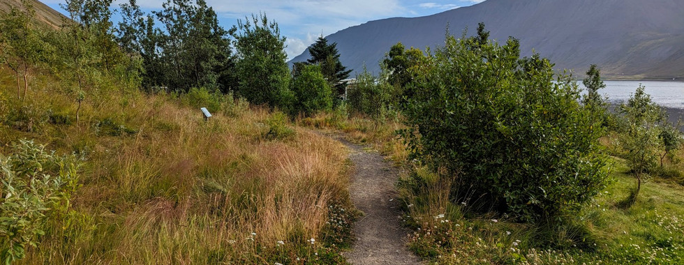
The Ski Lodge
Empty during hiking season and the start of the main trail. There is one road (dirt) to take which leads out of the lodge and takes you around the ski lift network.

The dirt road takes you up a hill, past the remaining ski lifts and ends at the last one. Now there is no more path and true Icelandic hiking.
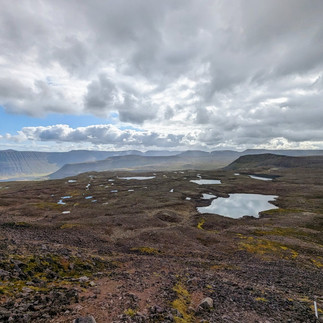
Lakes of Seljalandsdalur


It's all unmarked land until the end. Luckily the ground is mostly flat and has 4 lakes to help navigate. There will be random markers that have nothing to do with this trail. Don't be fooled by them. There will be beautiful greenery around water sources and wild Klofifa plants (middle picture above) sprinkled around.
The next step is the saddle which can be found by heading to the most northern lake and heading straight north some more.
Approaching Þjófar Saddle

As you get closer, the path will become visible for climbing over. The path is made by others trying their best to keep footing so do what you can to be safe. Details on saddle below
The Top


An amazing view. You literally saddle the top cause you will fall otherwise. I sat in the only spot that didn't make me cry so I could eat lunch. It was a Caesar salad (with pasta ... because Italian) with travel forks from my parents as a gift. Before continuing down, remember to sign the guestbook!


Hnifsdalur Valley


Once over the saddle, the remaining hike is beautiful and relaxing. Enjoy watching the views of Hornstrandir, waterfalls and rivers grow from more water sources as you descend into the valley. The key here is to keep right of the river until you find the gravel path that leads to town.

Obstacles
Þjófar Saddle


Saddles (or mountain passes) are the lower, thin points between two mountains that hikers can cross. In the western fjords they are usually steep and have loose dirt which makes footing difficult.

This saddle was quite steep and didn't have much room on top but the view was spetacular. Once uptop, there is a guest book for signing (I was too scared) and a few rocks to sit on for lunch.
Coming down to the Hnifsdalur side has a rope. This is needed since its a bit steeper and has a small drop that requires you to shuffle sideways to avoid.
IMPORTANT!! When shuffling, swing the rope to the side but watch out for any rocks the rope pick up because they will fall at your head.
Incline
Hike around the back of fjords require a lot of hiking up inclines. This can leave you tired and loosen up your concentration on footing.
Navigation

After certain points, markings disappear and you have to navigate topography maps and eyeballing the landscape. You can easily come to a steep descent and not realize it until the last minute.
Wrap Up
End Time: 4:30pm


The road into Hnifsdalur starts with a lonley farm in the middle of a patch of trees. Heading down I came across a jogger who seemed impressed by my accomplisments. Its nice to have someone in shape acknowledge my athleticism.


The trail ends in the village of Hnifsdalur. a small residential area with connections to the abandoned highway to Bolungarvik and a very well maintained footpath to Isafjordur.

There may be scooters in Hnifsdalur that can be used on the footpath but I had to walk for my case. Only 45 minute flat walk back to town so i wasn't mad.
Sadly there is no place to rest or a grab a bite to eat in Hnifsdalur . Keep that in mind when hiking.
360 Tour
From Ski Lodge in Isafjordur to Hnifsdalur
In the Area
Húsið
A casual atmosphere I will never get tired of. The perfect place to gather your thoughts and reflect. This was my den.

Details
Cafe with many options for food and drink
Great for any time of day
Staff is friendly and welcoming
I recommend the salad
Link:
Maps
AllTrails
Local Map
Notes: This is on F249, there are multiple river crossings.

Mapcarta
Very detailed Icelandic topography map.