Ísafjörður Hikes: Háafell Loop
- Zak Goldstein
- Apr 28, 2024
- 5 min read
Updated: Jun 21, 2024
Many lakes up in the highlands and for some reason, sheds for each of them! This hike takes you to the region southern region of Isafjordur which has a network of trails. Feel free to add on extra peaks and roads to make your own adventure.

DINK Details
This is an Icelandic hike so there is no path.
Difficulty: Medium Month: Sept | Time¹: 6 hours Distance: 11.12 mi Elv. Gain: 3,271 ft |
Obstacles: - Navigating. Things start to look alike.² | Prep: - Rain gear and boots - Download Hopp |
1. How long we took to walk it with breaks and all
2. Have GPS on the phone (don't need data).
A beach in the middle of the mountains......
Getting To Trailhead

Right in town. Feel free to park or scoot to any point off of route 61 on the south side.
If you want a scooter, there is no parking in this area. The closest parking is the airport. From the airport, you head south to the section seen on the map.
This approach takes you on the green path up to a junkyard. There is a split in the road and I took the blue path which went through a junkyard, over a fence, and through a field to another fence.
I recommend trying to walk the orange path. I could not find any documentation on this but the road "looked" more defined and led to the trail as well.


Just in case you want to take my approach, the blue path, it involves hoping two fences. I'm sure what I did was correct at some point in time but now it is probably easier to take the orange path.
The Hike
Start Time: 12:00pm

This trail starts off with an actual dirt path. It's used for cross country skiing during the winter. I would say it's more than other mountain trails since it leads to a lake but you will probably not run into anyone.

Maybe this road was once more maintained but nothing is using them now except for sheep. As I reached the end, the lake comes into view and it got windy.
The Windy Lake


WARNING: Loud
For some reason the wind picked up really bad. I was very lucky that a shed was there for protection. After waiting it out for a bit, I headed towards the right side of the lake and mountain to continue my hike. The next section is Icelandic hiking which has no path.
Pathless

I am a clown and tried to scale the mountain on the left side (the slope pictured above). Don't do that. Instead, try to head the the right in the picture, the slope is not as steep as it looks. The picture below shows the slope you should go down from right to left.

After heading around the mountain, there are some huge rocks to hope over which can be fun if you are careful. Then finally a little flat ground to rest up on.


The "Cross Roads"

This section has random stakes in the ground to help with navigation. There appears to be a network of them which get us to our destination.
Note: This is also the point for the extremely experienced trekkers who are looking to head to Sudavik via Svarfhétsdalur trail (I would never do this)

With a large river coming up, follow the markings. They take you around the thinnest crossing point and then the markings for this trail continued slightly to the right.


Here there are lots of tiny river crossings. Take your time. I did see a second trail, closer to the mountain on the left so if you don't have good footing, you could try heading there.
The Death Stranding Lake

A creation of Hideo Kojima, Death Stranding is a beautiful game inspired by the Icelandic landscape. As you explore Iceland, you can feel the inspiration Hideo took from his time here. Even more so as you get to more remote areas, you realize what inspired his vision.


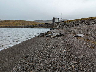
You would have no idea this lake with black sand beach would even exist without coming up here.


After the dam (pic above), a road for service vehicles will continue the hike.
A Rocky Path

The path takes me straight to the road so no guidance needed here. Optionally you can head right after the lake and look for the Haafell peak. It will add on at least an hour but it has trail markings to some extent.

The Old Highway and The Gun Range

I also messed this up. I recommend following the gravel road up to the abandoned highway. I got lazy and tried to cut across a field which turned out to be a very steep slope. This "shortcut" also because I found myself walking through a gun (airsoft?) range and river crossing.


If you do decide to cut across the gun rage, the river crossing is hopable in some parts so keep your feet dry and your head down (* The range was not operation in September).

Now we reach the main road back. The rest of the hike is all downhill and smooth ground.
Obstacles

Navigation
If you are new to trailess hiking, you can make little mistakes. There really is no point to ground your direction unless you pay attention.
I use AllTrails (with data off) with the phone's GPS so I had idea of where I am. I also took a picture of the local hiking map with markings from the experts at the information office.
This hike never put you in dangerous situations but some lost time means lost daylight. In hiking season, you can afford this with the extra sun.
Wrap Up
End Time: 6:00pm

This road drops you off to the west of our entrance. If you parked here, good for you. Otherwise, head to the main road and back towards the trailhead.
If you don't have a car, feel free to grab a bite at the supermarkets and pick up a scooter to head back.
360 Tour
The section around the back of Isafjordur
In the Area
SAM Versla

The polish supermarket! A great supply of kielbasa and pierogies. Defiantly relied on this place a few times.
Details
Great selection of polish food for grocery shopping.
A good selection of foreign foods and spices
Nice owner
Link:
Maps
AllTrails
Local Map
Notes: The green is the main path, orange is optional return. The Red is the dangerous Svarfhétsdalur path mentioned above.

Mapcarta
Very detailed Icelandic topography map: https://mapcarta.com/N5303462233
Side Note
Svarfhétsdalur Trail
Warning: This is the red section of the map, very dangerous. I wanted to document this for experienced and well prepared trekkers. Look for the trail from the Cross Roads section

The trail that cross to Svarfhétsdalur looks to go over this saddle. I'm comfortable saying, I will never see the top of that saddle but in case you are that type brave, this is what it looks like.