Staying in Þórsmörk: Básar, Húsadalur and Dealing with Krossá
- Zak Goldstein
- Apr 21, 2023
- 3 min read
Updated: Jun 21, 2024
The most beautiful land in Iceland! A green, scenic wonderland. Þórsmörk (Thorsmork) has many hikes and a few options for room and board. In our time here, we did 3+ hikes (Básar and Þórsmörk proper) and stayed two night at the Volcano Huts (Húsadalur).

DINK Details
Many hiking trails varying in difficulty. Choose wisely.
Deets: - Hiking destination - Cabins, glamping and camping | Bus / F-Truck / Walking: - Bus tickets - F249 road and rivers¹ - |
Plan Ahead: - Waterproof gear - Reservation for hotels - Reserve dinner or bring food to cook | Area Highlights: - A protect valley allows more vegetation than other places - Mountains and Volcanoes |
1. Need an F class vehicle for F-Class roads. A good one here too.
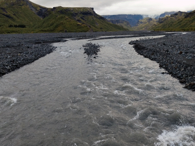
How the hell did he cross that fast? Water shoes!!
Getting There
Krossá River

You are NOT driving there. No. Don't. I know you and you can't. There is a special place on the internet for you if you try.
In the obstacle section I will explain why but for now you have 4 options.
The bus, the best option! There are many buses, tour and non-tour.
You partially drive to Básar, and walk across Krossá. This requires a good vehicle because there are smaller river crossings. We did this with a Jeep Wrangler, nothing less.
You walk there! There is a popular multi-day trail, Laugavegur trail, that goes from Skógar(foss) to Landmannalaugar. On the D.I.N.K todo list.
You are rich and buy a heavily modified tank that can actually cross this river. I cannot speak to this.
Bus
There are many bus options they pickup from Reykjavik and other costal towns. A nice service to get the most out of the south shore is https://icelandbybus.is/ . It's the closest you'll get public transportation in the wild.
An aggregation of many bus services: https://nat.is/bus-schedule-in-iceland/
Half Drive, Half Walk (We did this)
Driving (F249)

This is obvious on an F-Road. Please read up on these roads before driving them.
Conditions: https://www.road.is/
Road: F249
Warning: A month before our trip, a couple on their honeymoon died on this road during bad conditions. Please, watch the conditions !!
We drove a 4x4 Jeep Wrangler with 28cm of clearance. Read up on this as well not all F-class cars are safe on all roads.
Again, we did cross rivers but we did not cross Krossá with the jeep.
The road has a lot of river crossings which can get overwhelming if the weather adds to glacial runoff, so check road conditions and have backup plans. We were lucky enough to drive on some good days.


Walking Krossá
This is very doable, there are bridges that are moved based on water levels. Even doing this in the rain was not a problem.


Langidálur to Húsadalur
Once you finish crossing, you will end up at Landidalur camp. A very easy walk with 2 options based on your energy level, time or just how much you are carrying. The flatter Langidalur path north or the Valahnjúkur peak. We went the flatter path north since we had a lot of chili and booze in the backpacks. Only 25 min from one camp to the other and we went to the peak the next day.


Heading back, the weather was night and day.


Valahnjúkur

The Hikes

We picked out a major hiker per day when staying in Þórsmörk. Check out the articles on each.
Moderate effort to get to but very scary and more so in the rain.


In the heart of Þórsmörk. An easy and moderate section exist depending on how you feel. Have to cross the river.


The canyon, the volcano and the ravine. No major river crossing but still some rivers. Very easy and timely hikes. Nauthúsagil, the ravine, is easiest to get to.


Hotel
Volcano Huts in Þórsmörk

Our Details
45 min total walk from Básar to Langdalur to Húsadalur (Volcano Huts)
We stayed in the Sheepherders Cottages with kitchen. There's no ensuite but a bathhouse you can walk to across the lawn.
There was a lovely restaurant on premise.
Check-in was easy and we had a lovely view of the valley and sunset
Link:
For our 2 night stay, we dined at the restaurant once and cooked the other night. Lots of rain for the first night so lucky we got a hikes in already. We enjoyed a nice diner while we wait for the rain to subside.
The next night we experience an amazing sunset while I cooked the favorite, Pilsa Chili. It was easy to bring the ingredients and hot dogs don't go bad that fast.


Maps
AllTrails
Link: https://www.alltrails.com/trail/iceland/southern/basar-langidalur-husadalur-valahnukur?u=i&sh=gzd745
Note:
1) The bottom look can change depending on the bridge for Krossá.
2) The top loop are both options for getting to the huts. The break to the left brings you to an amazing view if you have time and energy