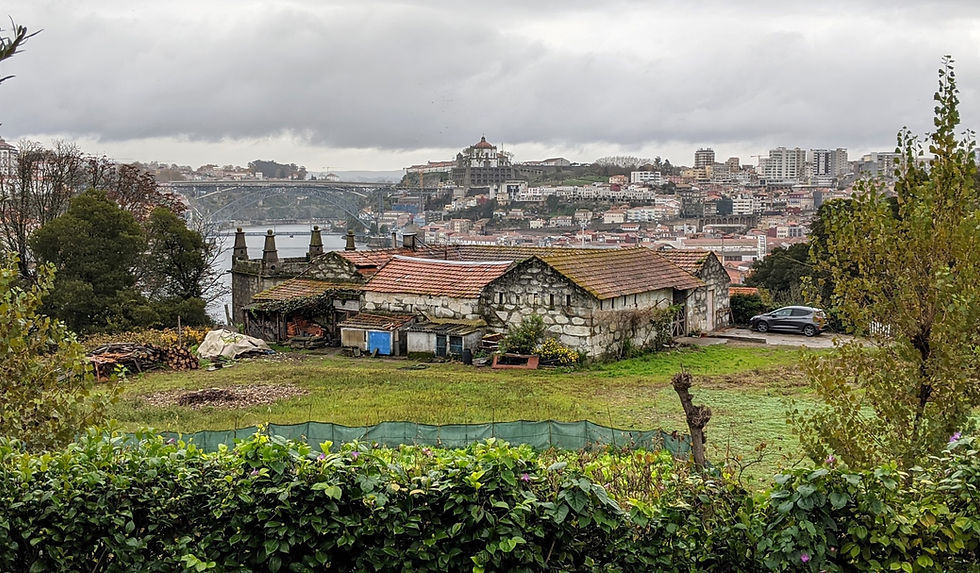
Azores in a Week: Hiking the Best of São Miguel Island
- Zak Goldstein
- Jun 21, 2024
- 9 min read

Updated: Jun 23, 2024
This island is full of unique, astonishing trails that are so easy to get to. From the famous Boca do Inferno to strolls around towns and lagoons, there is is a lot for everyone to hike.

DINK Details
For the relaxing details: Perfectionist Guide to São Miguel Island
Deets: - São Miguel is 1 of 9 Islands with trails - 30+ trails around the São Miguel
| Transportation: - Car rental recommended - Roads are paved around the island - The island takes 3 hours to drive around |
Prep: - Gear is not required. Most hikes are not too long and are well maintained.¹ - The weather can change rapidly. | Pro Tips: Hikes can get foggy. If you are here for the view, drive back a day later. Everything is a short drive away. |
1. Boots and some waterproof are helpful.
How did Japanese Cedar get here?
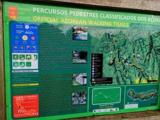
The Hiking System of Sao Miguel
The Azores have a detailed hiking system for each of their main hikes called the PR SMI trails.
The Official Trail List
A details list and of all the trails. Has some maps and up to date closures.
- Check fo closures: https://trails.visitazores.com/en/alerts
We needed more details and organization so....
Dink Trail List
The DINKs have put these trails into a more detailed spreadsheet with hike times and AllTrails links. They are also color coded by region so you can plan them together
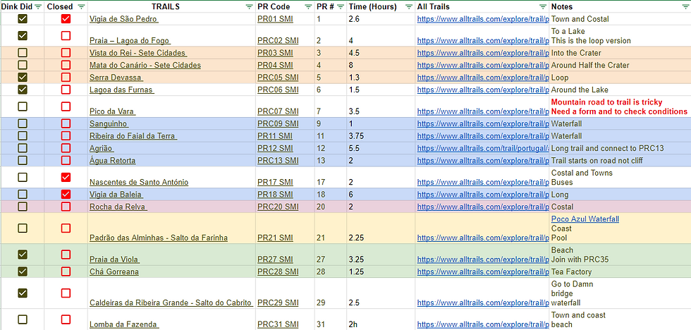
Dink Map
A Google map with locations of all the Sao Miguel trail heads and other points of interests nearby.
The DINK Trails
PRC02: Praia – Lagoa do Fogo

Trailhead and Trail Details


Distance: 6.8 mi
Elev. gain: 1,800 ft
Time: 4 hours
Type: Out and Back
An easy trail to follow with some moderate uphill in the beginning. Smooth sailing once in the middle.
It was a little scary driving up to the trailhead. The roads are small, the turns are sharp and the cliffs are high. The parking is quite limited. We got there at 10am and were hanging off the side of the road.
For after the hike, we recommend hitting up, Queijadas do Morgado - Home of the Queijada.
The Dink 360 Tour
The Hike


Hikes starts off with a strong uphill. Heading up switchbacks and through the Japanese Cedar (what is Japanese cedar doing half way across the world). Eventually this leads to the first water structure and views of the coast.
The rest of the way is follows the water channel through the forest. No more steep ascents, just the sounds of water flowing and easy hiking.
Eventually the forest ends and leaving you in clearing with more water facilities. Plants were starting get a bright green glow and if you looked carefully, you could get to see some cute frogs.


The Lagoon was gorgeous but it was the journey there that won our hearts over for this hike.
PRC05: Serra Devassa

Trailhead and Trail Details

Distance: 2.5 mi
Elev. gain: 600 ft
Time: 1.5 hours
Type: Loop
This hike features a great view of the east side of the island with many crater lakes. The trail is flat most of the time. Fog can form quickly and ruin the view so we stayed two nights in town to hike at the perfect moment. Make sure to hit up Miradouro da Boca do Inferno first!
At the top of Sete Cidades, this trailhead parking lot is shared with Miradouro da Boca do Inferno and it gets very crowded. We got there at 8am and had the place to ourselves.
The Dink 360 Tour
The Hike


The ideal hike for some easy views of the west side of Sao Miguel. This hike starts off through a muddy field with foot bridges to help out. I can see rain being a problem here.
The ascent up the mountain is easy and leaves you are a fork in the trail. If there is no fog, head right and get those good views in. Otherwise, head left for standard path with forest lakes and Pico do Carvão if you've got time. This path eventually heads up to the peak as well.
We managed to get some great views right before the fog rolled in.
Miradouro da Boca do Inferno

Trailhead and Trail Details
Distance: 1.6 mi
Elev. gain: 270 ft
Time: 45 min
Type: Out and Back
This is the "Hike of the Azores". The highest viewpoint of all the crater lakes in Sete Cidades. Not many places in the world look like this (and have accessible parking).
We stayed in town so we could wait for the fog to clear and drive up. Lucky for us it was at 8am so the trails were empty. The parking is shared with PRC05 (above) so feel free to hit up both hikes like we did.
The Dink 360 Tour
The Hike
Very easy, 20 minutes there and back. There is a lake along the way back and a restroom too.


PRC06: Lagoa das Furnas

Trailhead and Trail Details

Distance: 4.0 mi
Elev. gain: 350 ft
Time: 1.5 hours
Type: Loop
There are many places to start this trail. The official start point is in the town of Fernas but it was easier to park at one of the two parking lots on the lake (north and south). It says there is a fee but we did not see a collection point (maybe it's seasonal?).
If you have extra time, here are some activities around the lake
Parque Araucaria do Lulberto - A a garden that closes before sunset.
Fumarolas Lagoa das Furnas - Geothermal park
Railway Bar - Beer, thermal eggs and Cozido de Furnas on the spot
Parque da Grená - A network of hiking trails in the forest with waterfalls. Small entrance fee
The Dink 360 Tour
The Hike


We started at the northern parking lot by the geothermal activity. This allows you to explore the area, hike the extra trails and end by the cafe for a sip and bite of local food.
The walk itself takes you across paved roads and continuous views of the lake. Once you read the church, there is an entrance to a garden right before it. Its a couple of bucks and looks worth it (we got there too late).
Finally, head back up the road leaning to Furnas and grab a drink.
PR21: Padrão das Alminhas - Salto da Farinha

Trailhead and Trail Details
Distance: 0.8 mi
Elev. gain: 150 ft
Time: 1/2 hour
Type: In and Out
We only did a small section on this trail just to see Poço Azul. It's a pretty little lake that some people go swimming in and like its name indicates the water is VERY blue.
Parking around town is easy but don't park on the street with the cows. We parted 30 seconds up the main road in a giant circle.
The Hike


PR21 goes further out than we did but our trail is straight down to the bottom and the back up the same way. It was a very pretty hike and if it was hotter we would take a dip in Poço Azul.
PRC29: Caldeiras da Ribeira Grande - Salto do Cabrito

Trailhead and Details


Distance: 3.2 mi
Elev. gain: 500 ft
Time: 1.5 hours
Type: In and Out
Another favorite! Lots of parking, water, dam, bridges, waterfalls, watermills, and terrifying heights. We did not do the full loop since half of it was along the road. Instead we went to the dam and came back and then did the same for Salto do Cabrito waterfall. The views were great and we'd rather enjoy those that take a route along the road.
Parking was plentiful. The ideal spot is on the map but you can take a right turn before the Termas das Caldeiras for a lot more parking. If you are in the mood, there are geothermal BBQs in the ground for cooking.
Note:
This hike has some heights that were a little scary. Check the videos to see if you are comfortable
We did not complete the loop because the trail takes you along the long thin road we drove on to get there. Didn't seem worth it.
The Dink 360 Tour
The Hike
Part 1: Barragem Dam

From the huge parking area we headed south up the road. There is a split that goes left to the dam. To get on the correct path, there is road with a chain across. Hop over (its only to block cars)! The rest of the path is easy.


Very pretty structure to walk around. The path goes a little further back but after a small bit, it becomes impassable.
Part 2: Salto do Cabrito Waterfall

This hike took it up a notch! After returning to the cross roads from the dam, you head in the other direction into the the woods along a pipe. This eventually leads down to a small area with watermills and bridges.


Warning: This is where the heights start. The bridge was sturdy and very safe to cross. After a few more minutes another metal walkway appears over a pipe and that takes you to another very high gorge-like area where you cross over a waterfall, Salto do Cabrito.


Once crossed, there are a lot of stairs down to the base where a lot of people park and go for a dip in the water.
At this point we just headed back the way we came cause it was cool and the rest of the hike looked a little long and boring.
PRC35: Moinhos da Ribeira Funda & PR27: Praia da Viola

Trailhead and Trail Details
Distance: 3.6 mi
Elev. gain: 1,500 ft
Time: 2 hours
Type: One Way


These are two trails join in the middle and they are both worth doing! Unlike most trails, this is not a loop. PRC-35 takes you through a gorge with a reclaimed watermill and river crossing. PR-27 has a split by an abandoned watermill town (we took the high road).
We parked in Maia and took a cab (Hotel Sol helped us request) to the trailhead at PRC-35. Walking both trails leaves us back in Maia and a perfect lunch spot at Oestrela.
The Dink 360 Tour
The Hike
Part 1 PRC35


The main highlights on this section are the watermills which were taken by time. The next section's mills are more preserved. The path to the ruins are a dead end so remember to head back up to the main trail when you finish exploring.
The trail includes a river crossing with plenty of stones for stepping across. This means leaving the PRC35 and hiking up to PR27.
Part 2: PR27


The connection to PRC35 ends at a paved road with lookout, BBQs and a homemade bar that looks operational but only in season. This is where PR27 begins.


PR27 has a tiny abandoned village of watermills that you can just walk around freely! Around the back is a waterfall and inside the cottages are old millstones.
From the hillside village you can take the high road at the top or the beach path at the bottom. The trail split does not last very long and the beach path requires being conscious of the tides and a steep walk up hill.
The final stretch has a natural tiny pool if you want to take a dip and then ends at the bar and grill.
PRC36: Pedra Queimada - Lajinha - Degredo

Trailhead and Details
Distance: 2.0 mi
Elev. gain: 100 ft
Time: 1 hour
Type: Loop
This is a loop around the town of Maia. Very simple and if you bring a bathing there are two natural pools (ocean with rock protection from waves). Both have stairs but we didn't go in these pools. We did skip a section that heads south into the mountains so out time was shorter.
Park anywhere you can in town and start at any point really. Our hotel Sol had parking.
The Hike


Nothing to complicated on this hike, just loop around the field. There is a path down to the natural pools on the west side if you want to go for a swim. This is also a dead end so you'll be coming up the same way.
Once you get back to town, there is another natural pool by the rainbow stairs on the north side. This one has a ladder and is more popular.
Other Trails
PR01: Vigia de São Pedro

This trail was closed on the website. We picked up the very beginning and the end of it but skipped the middle. It looks fine except for the section of town that fell off into the ocean. This may be why its closed.
PR03 & PR04: Sete Cidades


Great walk around town but if you are parked here no reason to do the hike in our opinion. Lots of other hikes to do. Combining these two hikes takes you around the entire crater town. 03 does start at an abandoned hotel that's worth seeing
PRC07: Pico da Vara
The road was very rough, parts under construction and the Google maps didn't match the signs. We turned back, sadly but went to Cascata da Ribeira dos Caldeirões
PRC28: Chá Gorreana

A walking into the fields of Gorreana Tea Factory. Looks casual and you can park at the tea factory. We felt lazy so we did shots of liquor and got free tea inside.
PRC43: Pico das Camarinhas - Ponta da Ferraria

The area at the bottom is lovely with an interesting "spa". Might as well skip walking down from the top and just park at the bottom.